
Glen Dessarry Munros traverse
Bike along Glen Dessary to hike and scramble the Rough Bounds Munros of Sgùrr na Cìche, Garbh Chìoch Mòr, and Sgùrr nan Coireachan.
Route outline
| Munros | ||||
| Walk ascent | 1350m (4420ft) | |||
| distance | 13km (8m) | |||
| time | 5:30hr | |||
| Bike ascent | 160m (520ft) | |||
| distance | 16km (10m) | |||
| time | 1:30hr | |||
| Start/finish | Western end of Loch Arkaig Grid Ref : NM988916 | |||
| Terrain |
| |||
| Nav |
| |||
| Effort |
| |||
| Scenery |
| |||


Sgùrr na Cìche is the highest and most charismatic peak in the range presenting superb views from its summit including fantastic seaward panoramas over the islands of Eigg, Rum, Skye and beyond.
The setting of this route is remote, but is tamed not only by forestry tracks along the length of Glen Dessarry but also by a long parish wall and line of fence-posts flowing along the crests between the peaks.
Route map

Route description
1. Getting to Loch Arkaig

Car-park by end of Loch Arkaig
In the Great Glen, Gairlochy and its locks on the Caledonian Canal sit a couple of miles west of the Commando Memorial above Spean Bridge.
From Gairlochy the narrow B8005 heads up to Loch Lochy's southern tip then turns westwards. From here on a very narrow and unclassified road a 12 mile drive travels through the mossy Mile Dorcha then hugs the northern shores of Loch Arkaig to its western end.
The road ends by a gate across the access to an estate track, just before which is a large parking area with designated bays for around 15 vehicles. If the car-park is full, there are various verge side parking areas before reaching the car-park, but care should be taken not to block passing places.
2. Cycle through Glen Dessarry

River Dessarry
Leave the car-park, head around the gate at the end of the road and begin cycling westwards along the estate track. After just under 1km of cycling, the track comes to a junction  by a few right-of-way signs, turn left, downhill towards the buildings at Strathan.
Before coming to Strathan, take a branch in the track to cross a bridge over the River Dessarry then head into forestry. A short distance into the forest, another junction is met, turn right and cycle uphill on a track towards Glen Dessarry.
Cycle along the fine track for around 4km to the end of the forestry  above lonely A' Chùil Bothy. The track turns northwards, looses a little height and heads back into more forestry.

Bridge at end of track
 in a clearing and over a little gorge which can be quite impressive if river is in spate and fast flowing ! Leave your bike here.
Bridge at end of track
3. Sgùrr na Ciche

Approaching the gully below Sgùrr na Ciche
Over the bridge, and the track immediately becomes a damp path which splits upon re-entering the forest. Take left fork (the right fork is used upon the return) and follow the path aside the Allt a' Ghiubhais on its northern bank through forestry. The path is wet and soggy for much of its length in forest much of which is overgrown requiring some ducking and bending under low-hanging branches .
The end of forestry  is reached, and the path, now a mucky set of ATV tracks, meets with a path coming from northern side of Glen Dessarry. The tracks follow the Allt a' Ghiubhais upstream for just over 1km and splits - take the right fork heading uphill.
The track follows a burn upstream and becomes more defined as it climbs around 200m to then turn west  - leave the track at this point and keep climbing directly uphill following the burn. As the gradient levels, the burn source disappears into soggy ground.
Head in a northerly direction to meet with the Allt Coire na Ciche, the burn flowing down from Sgùrr na Cìche  . Turn north-east and begin to follow this burn upstream. A little gorge is entered in which a path can be found climbing aside the burn. Some of the ground is steep, bouldery and loose, but progress is fairly straightforward tracing the path as is twists and turns crossing the burn a few times.
Having climbed around 100m in the gorge, gradient easies and grassy terrain is met on the approach to the col of Feadan na Cìche  (meaning the 'whistle of the breast'), across which a wall crosses then travels around the north-eastern face of Sgùrr na Cìche.
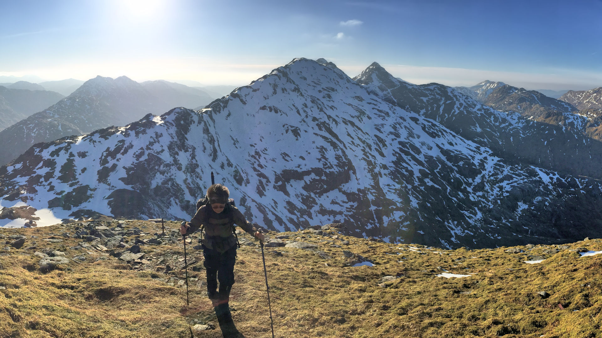
Above the col, turn west and trace an obvious path uphill on a grassy bank following a small watercourse. The path disappears into boulders and particularly if in mist, the way ahead may not be obvious - look right (north) and upwards and you should be able to pick out a route heading uphill over the boulders. As the boulders are left behind, the path becomes obvious again and is followed zig-zagging up steep loose ground to reach a small cairn on the crest of Sgùrr na Cìche's eastern arm.
By the cairn, turn left (west) and follow a path for around 200m to reach Sgùrr na Cìche's summit  where a small cairn stands offering little shelter out of any winds.

On Sgùrr na Ciche, looking over Loch Nevis
On Sgùrr na Ciche, looking over Loch Nevis
4. Garbh Chìoch Mor

Garbh Chìoch Mòr above Bealach na h-Eangair
Return along Sgùrr na Cìche's crest to the small cairn and re-trace your steps downhill back to the wall crossing Feadan na Cìche .
Ahead and uphill, the wall can be seen travelling southwards up the crest of Garbh Chìoch Mhòr's north-western shoulder. Just to the right of this wall, a path can be made out coming and going. Follow this path as it climbs gently at first, passing a couple of small lochans. Terrain underfoot becomes rougher and higher up there are some short sections of easy scrambling on grippy rock. Some impressive cliff and crag formations are viewed dropping northwards into the coire below.

On Garbh Chìoch Mor, looking back to Sgùrr na Ciche
 - the one marked by the smaller cairn !
On Garbh Chìoch Mor, looking back to Sgùrr na Ciche
5. Sgùrr nan Coireachan

Descending Garbh Chìoch Beag, Sgùrr nan Coireachan ahead
From Garbh Chìoch Mòr's summit, continue on the path following the wall eastwards and begin to lose some height. A slight rise on bouldery ground can easily be by-passed on the south side of Garbh Chìoch Mòr's crest, rejoining the wall further on.
Follow the wall up and over Garbh Chìoch Bheag  to drop down to Bealach Coire nan Gall
  . The wall ends abruptly and the path takes a slightly soggy route just below rock of the higher ground of the bealach.

Heading up Sgùrr nan Coireachan
 .
.Heading up Sgùrr nan Coireachan
6. Return

On Garbh Chìoch Mòr's summit, looking back to Sgùrr na Ciche
There are two options for the return to Glen Dessarry, the less steep of which is to return to Bealach Coire nan Gall and trace the Allt a' Bhealaich to drop down into bracken and to a rough path by the forests of Glen Dessarry. This path is then followed to the Allt Coire nan Uth.
A finer route begins by following a path along Sgùrr nan Coireachan's summit and along its southern shoulder. The path is vague as it descends ever steeper ground directly to the Allt Coire nan Uth.
Both these routes merge and keeping to the west bank of the Allt Coire nan Uth, follow a rough path downhill to the edge of forestry. Ignoring the very shoggly bridge (unsafe to cross on my last visit), head directly into the forest on a very mucky path to meet with the rickety old bridge over the Allt a' Ghiubhais and return by bike back along Glen Dessarry.

On Sgùrr nan Coireachan's southern shoulder, Gulvain in view
On Sgùrr nan Coireachan's southern shoulder, Gulvain in view
Maps and GPX downloads »


Route profile »

Weather forecasts »
| Regional | MWIS - Northwest Highlands |
| Peak specific | Mountain Forecast.com Met Office YR.no |
| Seasonal | SAIS - Lochaber Midge forecast |
Alternative and nearby routes »
Rough Bounds of Knoydart from Loch Cuaich | |
|
Challenging hike from Loch Cuaich Dam on stalkers paths to Sgùrr na Ciche and neighbouring Munros in the Rough Bounds of Knoydart. Peaks : 5 Munros, 1 Corbett
Ascent : 3240m (10630ft) Distance : 39km (24m) Time : 15:5hr* | |
Loch Arkaig Corbetts hillwalking route | |
|
Tackle the Corbetts of Sgùrr Mhurlagain, Fraoch Bheinn and Sgùrr Cos na Breachd-laoidh above Loch Arkaig in rugged Rough Bounds of Knoydart. Peaks : 3 Corbetts
Ascent : 1900m (6230ft) Distance : 20km (12m) Time : 8:10hr* | |
Càrn Mòr bike and hike via Glen Dessarry | |
|
Scenic bike and hike via Glen Dessary to Càrn Mòr above the head of Loch Morar and on the edge of the Rough Bounds of Knoydart. Peaks : 1 Corbett
Ascent : 1035m (3400ft) Distance : 25km (16m) Time : 4:45hr* | |
Sgùrr Mòr and Sgùrr an Fhuarain from Loch Arkaig | |
|
Hike from Loch Arkaig on stalker's tracks and paths to Sgùrr Mòr and Sgùrr an Fhuarain in the edge of the Rough Bounds of Knoydart's. Peaks : 2 Munros
Ascent : 1500m (4920ft) Distance : 21km (13m) Time : 7:45hr* | |
Bidein a' Chabair from Glen Dessarry | |
|
Bike and hike to Bidein a’ Chabair above Loch Morar via Glen Dessarry, cycling forest tracks then tackling rugged ridge terrain to its rocky summit. Peaks : 1 Corbett
Ascent : 1085m (3560ft) Distance : 28km (17m) Time : 4:45hr* | |
* Times shown are estimates – see timing notes on the disclaimer page for more information.

